

When the Los Padres National Forest announced a 60-day closure in four of its five ranger districts—encompassing a majority of its trails—after January’s storms, nonprofit Los Padres ForestWatch saw the need for a new informational service.
Any time there’s a large closure, storm- or fire-related, many members of the public who like to recreate outdoors tend to have a lot of questions about what trails are open and if they have limited access, said Bryant Baker, Los Padres ForestWatch’s director of conservation and research.
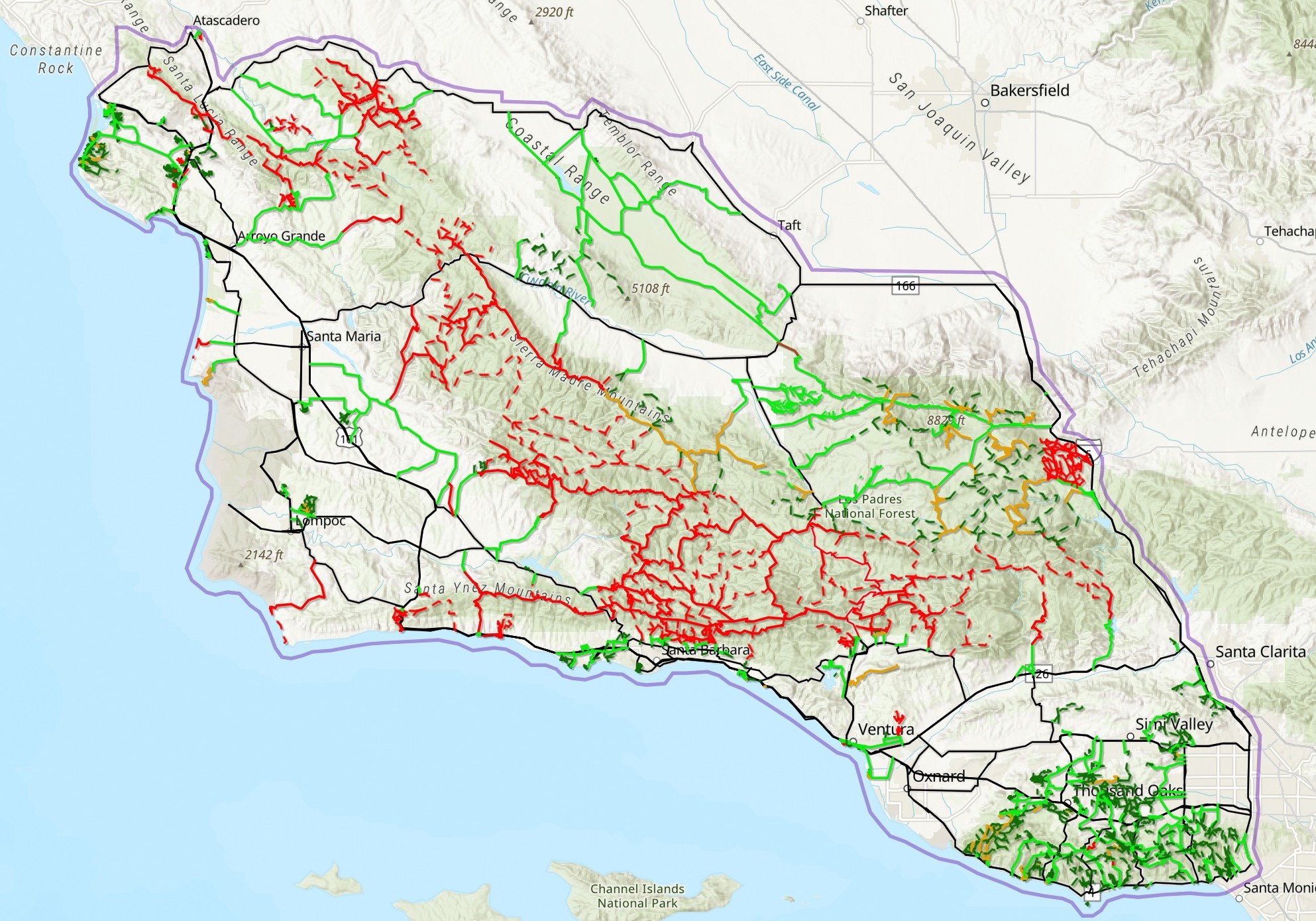
“There wasn’t this one-stop shop to figure out what trails and roads are still open and which are currently closed,” Baker said. “There’s a lot of different resources they can use to piece this information together. Every land management entity has some form of website where they post trail status updates, [but] some are better than others.”
This caused ForestWatch to launch OpenTrails: an interactive web app where people can see the status of roughly 1,800 trails and access roads that stretch from Morro Bay to the Santa Monica Mountains and inland to Carrizo Plain National Monument, he said. Most of these sites are located within the Los Padres National Forest and Santa Monica Mountains, but many are found in city, county, and state parks as well as nature preserves.
“I think knowledge is key; ‘know before you go’ is an important mantra in all of this,” Baker said. “We live in this amazing area with hundreds of trails up and down the coast. I want people to experience these new places but be equipped with knowledge before they start these adventures.”
For seven straight days following the storms, Baker said he pored over websites and databases in order to map out each trail on the site. He and Jeff Kuyper, ForestWatch’s executive director, continue monitoring city, state parks, and public lands websites to update the map daily. As of Feb. 1, OpenTrails received a little more than 5,000 views while only being available to the public for a week.
“This has been an idea for a while, but these big storms and all the damage they caused as well as the closure order provided this impetus and expanded our area coverage to know there are other areas besides the Los Padres [people] can go and recreate,” Baker said.
Once the 60-day closure lifts, Baker said ForestWatch plans to continue updating the app, as more storms are expected to come this year and fire season is approaching. Eventually, he said, he’d like to add the Big Sur region, trailhead and campground information, and trail mileage, and have it all accessible on an app that people can download to their phones.
“We’re super stoked about it. … We’ve made a lot of interactive maps, but this is the biggest one we’ve made. It’s very exciting for me and our one-person GIS [geographic information system] department,” Baker said.
As OpenTrails gains the public’s attention, Baker said he hopes this will also gain the attention of policymakers to inform them of the damage done to natural sites.
“Any time you can bring attention to the fact that a lot of trails were damaged, and there were big closures, that could help funnel resources to the places that need it most since there will be so many organizations fixing and maintaining trails,” he said.
Along with trail status, OpenTrails includes what type of recreation is allowed on the trails, websites with additional information, a colorblind-friendly palette feature, and a option to connect with ForestWatch to provide feedback, Baker said. He also encouraged people to double check official websites to make sure the map is accurate before heading out.
“I don’t want people to think this is their one and only place they should go to find out information about trails, parks, and places to recreate; it’s more of a starting point to figure out what areas are still open, and then I encourage people to try and get more information about the trail,” he said.
Visit lpfw.org/trails to access the map and explore what trails are open. Direct questions or comments about the map to [email protected].
Highlight
• The city of Santa Maria Recreation and Parks Department will continue its popular Rec on the Move program through February. Rec on the Move is a safe, supervised program where elementary school-age youth participate in free games and physical education activities, which will take place from 3 to 5 p.m. at Buena Vista Park (Mondays), Bob Orach Park (Tuesdays), Tunnel Park (Wednesdays), Newlove Community Building (Thursdays), and Russell Park (Fridays). Registration isn’t required to participate, and rain will cancel programming. Direct questions to (805) 925-0951, Ext. 2260.
Staff Writer Taylor O’Connor wrote this week’s Spotlight. Reach her at [email protected].
