There is an art to science, they say, and one of the earliest intersections between the two seemingly separate fields was cartography. The earliest maps always had an artistic flair to them, whether it was the incredible accuracy cartographers could achieve or the ornate compass roses that adorned them.
The Los Alamos Public Library is currently showcasing a very small portion of the work of one of the last century’s most prolific cartographers. A local boy, Thomas Wilson Dibblee Jr. was born in Santa Barbara in 1911. He was a descendant of none other than Captain Jose de la Guerra y Noriega, the comandante of the Presidio of Santa Barbara. He grew up on the ancestral Rancho San Julian land, and gained an interest in geology at a young age when a geologist came to the family property to look for the possibility of oil there.
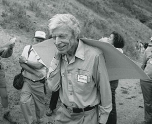
That was the very beginning of a nearly 70-year career in geology, surveying, and map making, explained Stephan Bedford, owner of Bedford Winery in Los Alamos, who also owns most of the framed maps currently showing at the library there. Bedford knew Dibblee, who passed away in 2004, and purchased the maps of the geography and geology of the area, which interests and concerns him as a winemaker.
“He was so gracious. For me, he was one of the great ones,” Bedford said. “He could go around, and would be so observant, and look around and see things that nobody else would see, but then he would be patient enough to explain it to you. And that’s what those maps do as well, it’s an attempt to make something visible.”
Dibblee worked for a number of petroleum companies across his career before settling at the U.S. Geological Survey. During his time there, he mapped tens of thousands of square miles of California wilderness. He gathered his data mostly on lone expeditions, and he was marveled at for his spartan supplies and endurance, often spending weeks alone in the wild.
But it’s the maps that really impress geologists, cartographers, and artists alike. The incredible accuracy that Dibblee achieved makes his maps an authority still in use today despite satellite imaging. The U.S. Geologic Survey and the California Department of Conservation, Division of Mines and Geology collaborated to colorize Dibblee’s maps, illustrating the types of soil found across the topography that Dibblee so masterfully documented.
“I think it’s artistic because of the craftsmanship,” Bedford said. “You look at it, with all the colors and all the information there, and it is sort of fantastic.”
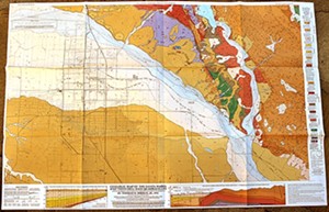
The exhibit is titled Artistic Works of Science, and is a continuation of the mission that the Friends of the Los Alamos Library laid out when the library opened in 2015. The organization wanted the library to serve as a showing space for art, but also for artwork or information of historical or cultural relevance to Los Alamos and Santa Barbara County.
The co-curators for the art series are artists Karen Gearhart-Jensen and Kam Jacoby, who were both a part of getting the library revitalized and reopened. The two have made sure that the shows at the library have been varied, including some artful photography, an exhibit about architecture, and another about the history of transportation in the county.
“We’re interested in not only the art aspect of it, but in having it be educational and enriching to the community,” Jacoby said.
“We don’t have a community center per se, or a general meeting area for the community, and so our hope was that the library might be a magnet for that on some level,” Gearhart-Jensen added.
The maps and other interpretive information provided by the Santa Barbara Natural History Museum, which runs the Dibblee Geological Foundation, show in the main library and in the children’s area. Maps also show just above tables where students can take advantage of an after-school tutoring program, Jacoby and Gearhart-Jensen explained.
Artistic Works of Science includes maps of many familiar landscapes, from Los Alamos to the Santa Maria Valley. The exhibit has piqued the interest of many, including Santa Maria City Librarian Mary Housel, who remarked on the possibility of featuring a small selection from the show at the Santa Maria Public Library in a display case after its run in Los Alamos.
“A lot of people haven’t heard of Dibblee and haven’t even thought about maps and how there might be a quality about them that may be artistic,” Housel said. “And the beauty of it is for people in the community who don’t have transportation out of the community, this becomes a central place where they can come to find museum-quality shows. In addition to being a library, it is a museum of sorts.”
The maps are incredibly detailed, and those who take the time to read the color key along the margins can learn about the geology and topography of the area. There are geology books at the library for cross-referencing and education of course, so unfamiliar words can be demystified on the spot.
And for someone like Bedford, who originally purchased the maps for his own understanding, spending time learning about the local land can also tell something about the people living on it.
“It expresses what the community is about and it adds depth to the community,” Bedford said. “This is our area right here, and it shows you everything about what’s happening, from where the oil comes from, where the aquifers are, where the farming is, where the soils are, and for me, why there are such great vineyards here. All of this is shown on these maps—what epoch and what age these alluvial planes have come from.”
Arts Editor Joe Payne enjoys a top-down view and a scientific perspective, especially when it’s artfully done. Contact him at [email protected].
